Google Maps and OpenStreetMap
Introduction
OpenStreetMap
Solution to provide list of addresses as input, have each location be displayed in the map as numbered pins, save the map for offline use and print it on paper?
At least three options:
A.
1. add the stuff I want to see into OSM database
2. download the OSM data in Osmand ("OSM Automated Navigation Directions"; "a tool to search osm data by name and address and to generate synthetic addresses of osm points (reverse geocoding)") and use that for searching and figuring where I want to go
B. create a GPX file with favorites and place them on the SD card in a file named osmand/favorites.gpx. There are many tools to create GPX files, you can search for convert KML to GPX to find something that works.
If you really want a printed map, you'll need some coding experience.
C. With Nominatim, you can ask for an address (or POI name), and get the position back. So if you put this in a script, you can create a list with positions and names. Afterwards, you can create a simple leaflet webpage ("modern open-source JavaScript library for mobile-friendly interactive maps") which displays these locations on a map. This map can be printed (or at least via a screenshot) on paper.
OpenCycleMap
Google Maps
Downloading maps for offline use
It's possible to pre-download the map of an area so that it's available without an Internet connection:
https://support.google.com/gmm/bin/answer.py?hl=en&answer=2650377
Offline maps can be used with GPS, which doesn't require an Internet connection.
Showing location without a map
Sometimes, we just want to show a single location with a pin. In that case, creating a Google Map is overkill. An alternative is www.pininthemap.com:
- In Google Maps, find and copy the GPS coords for the location
- In PinInTheMap, paste the coords: You can now just copy/paste the URL provided by PITM.
Numbering locations
As of January 2013, Google Maps doesn't support numbered pins. It only lets you change the icon used for a given location through its "Add an icon", but this must be done manually for each location; Besides, it won't watch for mistakes (ie. selecting the same number for two locations) and won't let you reorder the list.
Until someone comes up with a better way, a solution is to use Taurich's web application:
 |
- In Google Maps, add locations with default unnumbered pins. You might want to order locations by area to minimize walking
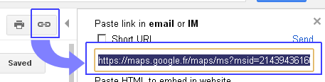
- Copy the map's URL by clicking on the chain/link icon, head for Taurich, and paste the URL
- Zoom out so that all the locations are displayed, and copy the list of locations at the bottom half into your word processor
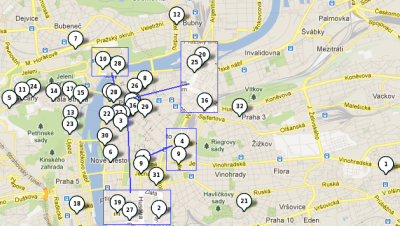
- Take a screenshot of the whole map; If some locations are too close and overlap, zoom in, take a more detailed screenshot, and combine it with the bigger screenshot of the whole thing.
Here's an example with Prague:
ALTERNATIVE? Google Maps imports data in KML, KMZ, or GeoRSS